Monday, December 12, 2011

hunza wood


Sunday, September 25, 2011

Hunza Peak

Hunza Peak lies in the westernmost subrange of the Karakoram range along with the Ladyfinger Peak (Bublimating). It lies on the southwest ridge of the Ultar Sar
massif, the most southeasterly of the major groups of the Batura Muztagh. The whole massif rises precipitously above the Hunza Valley to the southeast.
Bublimating, while having little prominence above the saddle with nearby Hunza Peak, is particularly notable for being a sharp, relatively snowless rock spire among snow peaks.
This peak has at least two known routes, both climbed in 1991. Both routes where done in alpine style, the first by a Swedish expedition and the second by a British team, which included Caradog Jones and Mick Fowler.

Saturday, September 24, 2011

The Aga Khan Silver Jubilee Band

The Aga Khan Silver Jubilee Band, Gulmit was established during 1990s. The main purpose of this band was to entertain the community during different events particularly during Salgirah programmes. During earlier time the people who were the member of Hunza Band Karachi trained the local youth. The office of the band is now in the first historical school building in Gojal. Presently Gul Bayaz is Captain of the band.

Wednesday, September 21, 2011

LIFE IN HUNZA

Hunzakuts are photogenic and look very attractive in their traditional dresses. Men wear baggy shalwar and qameez with a typical rolled woolen cap called pattu. A long coat or blanket is worn in winter. Women wear bright clothes: a long shirt over baggy trousers and an embroidered hat, over which they drape a shawl. They do not observe veil and work as equals in fields and homes. Hunzakuts get a little time for entertainment as they spend more time at work. Nevertheless, they celebrate many festivals of harvesting and sowing. They like to sing and dance at weddings. Their local orchestra consists of a big drum, kettle drums and pipes.


Hunzakuts are simple and contented. They still believe in fairies and supernatural powers. Their folk tales and songs are based on accounts of fairies. They are humble and hardworking. Fear, fatigue and crime are not known to them. Christine Osborne relates a very interesting incident to show the simplicity of life in Hunza,


"Out for a stroll, I passed an elderly woman struggling uphill with tins of sloshing water. Instinctively I took them, motioning her to lead as she hopped from rock to rock like a tiny ibex. Her small house stood on a cliff in upper Karimabad. It was clean, but lacked any comforts. She had a roof over her head, but with only a bedroll, a plate and mug, she owned little more than a nomad. Squatting on the dirt floor, she spoke through the usual boy interpreter. She lived alone, never wore shoes. And her age? 'Three hundred and ten', he said in perfectly accented English!"

Though exaggerated, longevity of the Hunzakuts is proverbial. In Hunza, one may come across many old people at the peak of their health. When asked their ages, they will not set it below ninety. One hundred is not a rare figure. However, according to the research of Dr. Muller Stellrecht, tales of people living great ages are not true. Some may survive to live seventy and even ninety years but tales of centenarians are false. Somehow, Hunzakuts are healthy and strong. It is largely due to their vegetarian diet of cereals and fruits. They do suffer from goiter, tuberculosis and bronchitis but mostly meet their natural deaths.


Hunzakuts live in gray mud-rock houses. Most of the houses have two or three stories. The people live in lower storey in winter and upper storey in summer. Usually, they do not keep windows or ventilators but a skylight in the roof. Houses face west with their backs to cold Ultar Glacier. Verandas and roofs are used for drying apricot and maize.

Cattle breeding and farming are popular professions in Hunza. Sheep, goats, yak and horses are domestic animals. Hunzakuts use sheep wool and goat hair to spin a rough cloth. This is used to weave caps and long coats. Traditions are still intact. Men spin goat hair and women only sheep's wool. Despite brief summer, industrious people of Hunza cultivate two crops a year. They work in terraced fields, which rise from the foot of hills to the top. Each terrace is walled with stones. Hunzakuts work long hours in their fields moving from one terrace to the other. One can count as many as thirty terraces in a single field.

Before the British occupation, a reasonable arms industry also existed in Hunza. Skillful craftsmen used to manufacture old muzzle-loading rifles. However, the profession is dying out slowly. Christine Osborne cites General Hamid's interesting description of the old rifles in these words:

"There is nothing like it in the rest of the world…The trigger is fixed somewhere near the end of the butt. When it is pulled, it brings down a big semi-circular hammer. The trigger and hammer are so situated that an inexperienced man using the gun might have his nose caught between the hammer and the butt… The owner of the gun has to carry such additional items required in connection with the firing… a pouch for the gunpowder, pieces of iron or garnets to be used as pellets, a piece of flint, an iron edge tightly secured in a wooden handle, cotton wool for wicks etc… A wick impregnated with a little powder is tied to the cocked hammer of the gun…When the trigger is pulled the dangling wick descends. When it correctly falls into the upper recess containing some powder, spark is produced which, traveling inward into the barrel, fires off the main charge. It will thus be seen that several conditions must get fulfilled before the gun can be made to fire… any bird or animal which allows itself to be shot with this gun deserves death… the animal must be either asleep, deaf…and requested to keep still for a few minutes while the whole process of shooting is gone through."

Tuesday, September 20, 2011

Hunza Adventure


Hunza, a remote mountain kingdom, may have been the inspiration behind James Hilton's "Shangri-La." The area opened up in the 1970s following the completion of the Karakoram Highway (KKH); an engineering marvel tracing the old silk route from Pakistan into China.

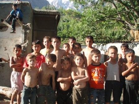
The fair skinned and light-eyed Hunzakuts claim to be descendants of soldiers lost from Alexander's army as he invaded India. Their language, Burushaski, provides linguists an enigma as it is unrelated to any other language known to man.

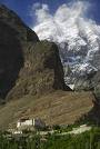
The beauty of this mountain paradise is matchless; from the soft blossoms of the apricot trees to the dark snowcapped rock monuments of Rakaposhi (7788 m.) and recently climbed Ultar (7388 m.) jabbing a vivid blue backdrop high above.

We begin our journey with a plane flight from Islamabad to Gilgit. If weather does not permit the flight, we will travel via the famous KKH. From Gilgit we proceed over the Karakoram Highway to Karimabad (2440 m.), capital of Hunza. En route Rakaposhi appears with its sheer ice covered walls to awe passersby.

One night is spent in Karimabad before we begin a brief, but strenuous walk to the base of Ultar Peak. We camp for two days on the high meadows overlooking Hunza valley and then return to Karimabad ready for our next adventure.

A short drive on the KKH takes us to Passu where we begin our trek on the Batura Glacier (63 km.). We spend about a week on the Batura; walking over rocks and sand laid between jagged peaks, through pine strewn hills with occasional wild roses, to high shepherd meadows with staggering views of the Batura massive and the largest ice fall in the world. The people in this area are of Persian/Turkish origin and speak a language with ties to Persia. The Wakhi people are very hospitable with bright pink cheeks topping a ready smile.

The last segment of this journey begins with our return to Passu or Gulmit village. After an overnight rest there, we drive on the KKH to the Khunjerab Pass (4833 m.) on the border between China and Pakistan. After enjoying the rolling green highlands, we return the same day to Karimabad. An overnight stay in Karimabad and then on to Gilgit by means of the KKH.

The last leg of our trip takes us back to Islamabad by plane or road depending on the weather. The Hunza adventure is a grand introduction to the mountains of Pakistan. The traveler follows the most spectacular segment of the ancient silk route through an enchanting mountain kingdom to Pakistan's border with China. The Batura Glacier provides a glacial excursion with less difficulty than either the Baltoro or Biafo-Hispar glacial traverse.

Detailed Itinerary - Hunza Adventure

Day 1, Rawalpindi/Islamabad

Hotel, trek briefing. We will have ample time for sightseeing and shopping in colorful old bazaars of Rawalpindi and new markets of Islamabad. We may also drive to the huge modern Faisal Mosque in Islamabad.

Day 2, Gilgit (1,500 m 4,920 ft)

Hotel, flight. One of the most thrilling mountain flight in the world. We will fly in a Fokker Friendship turboprop plane which seats about 40 people. The plane flies at an altitude of about 4,500 m. in the Indus valley. It is surrounded by high peaks including Nanga Parbat (8,125 m.). In Gilgit we have time to shop and do some sightseeing.

Day 3, Karimabad (2,440 m 8,000 ft)

Hotel, drive. This is a 3 hour drive into the heart of the Hunza valley. Rakaposhi (7,788 m.) towers above the KKH. Hunza valley is a Shangri-La!

Day 4, Ultar (3,600 m 11,800 ft)

Camp, trek. Today we will climb up to the Ultar meadows over looking the Hunza valley. This is a brisk and steep climb behind Baltit Fort. It takes about 4 hours of trekking.

Day 5, Ultar (3,600 m 11,800 ft)

Camp, rest. Nice day just to relax in the beautiful surroundings. We can mingle with the shepherds here. The mica Ultar Glacier lies in front of us and the Ultar peaks along with ‘Ladies Finger’ towers above us.

Day 6, Karimabad (2,440 m 8,000 ft)

Hotel, trek. After our quick two day trek up the Ultar Meadows we now return to Karimabad. This gives us a day to relax and shop in local bazaars.

Day 7, Pasu (2,400 m 7,870 ft)

Hotel, jeep. A short couple of hours drive up the KKH brings us to the village of Pasu. The view of Tupopdan needles towering above the Hunza river in Pasu is breathtaking. In the afternoon we have time to walk in the old village.

Day 8, Yunzben (2,700 m 8,860 ft)

Camp, trek. The Batura Glacier trek begins. It takes about 4 to 5 hours walking on dusty trails at the snout of the huge Batura Glacier. The Batura is even longer than the famous Baltoro Glacier in the K2 region.

Day 9, Yashpirt (3,100 m 10,170 ft)

Camp, trek. Today we diagonally cross the Batura Glacier. This is a tiresome day with lot of walking on rocks and the moraines of Batura. Yashpirt is a beautiful high meadow with many shepherd huts and fantastic views of the Batura peaks and the famous Batura ice fall across the glacier from us. We can also see Distaghil Sar (7,885 m.) from here. Distaghil Sar is the highest most western mountain in Trans-Himalayan and one has to go around the globe to come back to the eastern Himalaya to find such high peaks. Today’s walk takes about 6 to 8 hours.

Day 10, Guchashim (3,400 m 11,160 ft)

Camp, trek. This takes about 4 to 6 hours and involves crossing mountain streams. On the way we see families from Pasu with their yaks, sheep and cows in their summer homes. On our right is the ever present huge Batura massif wall.

Day 11, Guchashim (3,400 m 11,150 ft)

Camp, rest. We have ample time to wash, read and just explore the beautiful and awesome environment. Some go a little higher for a day hike to visit a side valley.

Day 12, Yashpirt (3,100 m 10,170 ft)


Camp, trek. Return to Yashpirt camp.

Day 13, Yunzben (2,700 m 8,860 ft)

Camp, trek. Return to Yunzben camp.

Day 14, Pasu (2,400 m 7,870 ft)

Hotel, trek. Return to Pasu for some rest.

Day 15, Karimabad (2,440 8,000 ft)

Hotel, jeep. Leaving early morning by jeep we proceed to the famous Khunjerab Pass (4,833 m.). After touching China at the highest paved border crossing in the world where the Pamirs meet the Karakoram we return to Karimabad on KKH. We arrive back in town in the late afternoon.

Day 16, Gilgit (1,500 m 4,920 ft)

Hotel, drive. We return to Gilgit and have ample opportunity to visit the Central Asian bazaars and do some sightseeing.

Day 17, Rawalpindi/Islamabad

Hotel, flight and trek debriefing. Here we go again and find ourselves looking forward to being on this world famous flight. One can never get enough of the sight of Nanga Parbat which is so huge that the plane takes about ten minutes to cross its northern face!

Note: On day 17, if the weather is bad and flights are canceled then we will leave Gilgit by road on KKH to return to Rawalpindi/Islamabad. This will be a long day and we will arrive back in Rawalpindi/Islamabad sometimes during late evening of the same day. On the other hand the flight takes under 2 hours.

This is a tentative itinerary. For the enjoyment of your trip a ‘go with the flow’ attitude is necessary. Many factors will influence your trip, such as weather conditions, health, route conditions, etc. Please do not take this itinerary very seriously!

Sunday, September 18, 2011

Hunza Guide Line

the guide line to the tourist from all over the world that how to get to the hunza valley is as follows.
if tourist enters the islamabad airport then either he should buy a air ticket if he or she wants to fly to the gilgit or else if anybody wants to get to gilgit or hunza by road then he has to buy a ticket of bus which is approx Rs 2100 from rawalpindi to hunza,after buying the ticket the bus leaves rawalpindi at 2.00 pm for hunza. the bus travels through KKH and passes through different cities of KHYBER PAKHTUN KHWA province.it takes almost 18-20 hrs to reach Hunza because of the rough road and the maintainence of Karakurum Highway.After 20 hrs of journey it enters the land of beauty called as HUNZA. In Hunza the karimabad is the most visited place which is the capital of Hunza and where most of the tourist stay and dine. if you want to have a stay at a hotel then you need to think that which hotel you want to stay at. there are many hotels of different range. the range is from 200-4500 and it depends on the different qualities of the hotels.

Wednesday, September 14, 2011

BALTIT FORT

The Mirs of Hunza abandoned the fort in 1945, and moved to a new palace down the hill. The fort started to decay and there was concern that it might possibly fall into ruin. Following a survey by the Royal Geographical Society of London, a restoration programme was initiated and supported by the Aga Khan Trust for Culture Historic Cities Support Programme. The programme was completed in 1996 and the fort is now a museum run by the Baltit Heritage Trust.


In olden times a number of small independent states existed in the history of Northern Areas of Pakistan. Among them Hunza and Nager were the traditional rival states, situated on opposite sides of the Hunza (kanjut) river. The rulers of these two states, known as Thámo / Mirs (Thάm=S), built various strongholds to express their power. According to historical sources (Ref: Tarikh-e-Ehd Atiiq Riyasat Hunza by Haji Qudrarullah Baig, Pub: S.T.Printers Rawalpindi 1980 Pakistan), the Hunza rulers initially resided in the Altit Fort, but later as a result of a conflict between the two sons of the ruler Sultan, Shah Abbas (Shάboos) and Ali Khan (Aliqhάn), Shaboos shifted to the Baltit Fort, making it the capital seat of Hunza. The power struggle between the two brothers eventually resulted in the death of younger one, and so Baltit Fort further established itself as the prime seat of power in the Hunza state.

The rich beauty of Baltit Fort can be traced to over seven hundred 700 years ago. Ayasho II, Tham / Mir of Hunza in the early 15th fifteenth century married Princess Shah Khatoon (Sha Qhatun) from Baltistan (In Moghul history Baltistan is called Tibet Khurd mean, little Tibet), and was the first to modify the face of Altit and, subsequently Baltit Fort. Baltistan meaning land of Balti people had a very strong cultural and ethnical relation with the Ladakh territory of India then. Consequently, the structure of Baltit Fort was influenced by the Ladakhi / Tibetan architecture, with some resemblance to the Potala Palace in Lhasa. Then additions, renovations and changes to the building were being made through the centuries by the long line of rulers of the Hunza that followed.

A veritable treasure house for ancient forts, the Northern Areas of Pakistan lost most of its glorious built heritage around the 19th century as a result of the destructive attacks by the Maharaja of Kashmir. However, in this regard people of Hunza were exceptionally fortunate to successfully defend against the invasions of Maharaja Kashmir four times. One of the biggest changes in the structure of Baltit Fort came with the invasion of the British in December 1891. Tham / Mir Safdarali Khan, ruler of Hunza his wazir Dadu (Thara Baig III), fled to Kashgar (China) for political asylum with their fellows and families. With the conquest of Hunza and Nager states by the British forces in December 1891, the fortified wall and watch towers of the old Baltit village and watch towers of the Baltit Fort on its north-western end were also demolished as desired by the British authorities. The British installed his younger brother Tham / Mir Sir Muhammad Nazim Khan K.C.I.E, as the ruler of Hunza state in September 1892 [1].

During his reign, Tham / Mir Nazeem Khan made several major alterations to the Baltit Fort. He demolished a number of rooms of third floor and added a few rooms in the British colonial style on the front elevation, using lime wash and colour glass panel windows. The Baltit Fort remained officially inhabited until 1945, when the last ruler of Hunza, Mir Muhammad Jmamal Khan, moved to a new palace further down the hill, where the present Mir of Hunza Mir Ghazanfar Ali Khan (Current Chief Executive of Northern Areas) and his family are residing.

With no proper authority entrusted to care for it, the Fort was exposed to the ravages of time and over the years its structure weakened and began to deteriorate. His Highness Aga Khan IV initiated the restoration efforts for Baltit Fort in 1990, when Mir Ghazanfar Ali Khan the son of last ruler of Hunza, Tham / Mir Muhammad Jamal Khan and his family generously donated the Fort to the Baltit Heritage Trust, a public charity formed for the explicit purpose of owning and maintaining the Fort. The restoration undertaken by the Aga Khan Trust for Culture in Geneva in association with the Aga Khan Cultural Service Pakistan (Pakistan), took six years to complete. The project was supported by the Aga Khan Trust for Culture as the main donor through its Historic Cities Support Programme, as well as by the Getty Grant Program (USA), NORAD (Norway) and the French Government.


The restored Fort, resplendent in its regal glory was inaugurated on September 29, 1996 in the presence of His Highness the Aga Khan IV and the president of Pakistan Farooq Ahmad Khan Laghari. It is now operated and maintained by the Baltit Heritage Trust and is open to visitors. Preservation at its best, the Baltit Fort serves as a perfect example of culture restored and preserved for the future generations of the mountain people.

Tuesday, September 13, 2011

HAIDER INN HOTEL

This is one of the original hotels in Hunza and the friendly owner is happy to show you the one-room original Haider Inn and the original travellers' menu. The rooms vary but overall are good value,
thay have hot water and sepacal powar cuniction.

Room par day..........400 Rs
Domatary................150 Rs

Wednesday, August 24, 2011

KARAKORAM HIGH WAY


Silk Route - a fairy tale like travelers' dream route from Central Asia to the rest of the world. It existed as trade link between the East and the West around 100 BC and lasted until the 15th Century, when with the invention of ships, the trade became more cheaper and easier than the rugged mountains through which the Silk Route passed. Since mostly the traders from the West imported the Chinese silk, the route became to be known as the Silk Route. Besides trade, the route was also used by the explorers, invaders, missionaries and philosophers.. Buddhism, Islam and Christianity mainly came to this region through this trade linking route. The Zero Point of the route started from Xian in China through the great Gobi Desert to Dunhuang, where it bifurcated via Taklamakan Desert to Kashgar and through Yarkand to Kashgar.
It is from Kashgar that it entered the subcontinent over the Pamirs and the Karakoram Mountains. China and Pakistan became long time strategic friends when President Ayub Khan of Pakistan visited China in 1964 and soon both great countries realized that a north - south link from China to the Arabian Sea can become a reality with the revival of the old Silk Route. Thus in 1966, Pakistan and China agreed to construct the KKH - the Karakoram Highway. The KKH has opened up remote villages where little has changed in hundreds of years, where farmers irrigate tiny terraces to grow small patches of wheat, barely or maize that stand out like emeralds against the grey, stony mountains. One of the workers narrates an interesting anecdote about the remoteness of the area. When after lot of difficulties, a Pakistan Army jeep managed to reach a so far inaccessible village, a villager ran and brought a vase full of water and placed under the front of the jeep. When asked what he was doing, the villager innocently replied, "Sahib, your animal must be thirsty."

kkh map

kkhThe 1300 kilometres (800 miles) long KKH, or the N-5, originates from Hassan Abdal, a place some 45 kilometres from Islamabad on the Islamabad - Peshawar Highway, goes through Abbotabad, Manshera, crosses the River Indus at Thakot, on to Gilgit (through Besham, Pattan and Sazin) and then to Chilas, Hunza and Sost before crossing the Khunjerab Pass at the height of some 4800 metres (15,750ft) - the Zero Point between Pakistan and China. It then enters the high Central Asian plateau before winding down through the Pamirs to Kashgar, at the western edge of the Taklamakan Desert. It is a marvel of human endurance, ingenuity and determination. Both Pakistani and Chinese workers and engineers worked day and night over some of the most formidable and inaccessible mountain ranges of the world, with deep gorges and torrential Indus running along the track with its full might. The Indus River flows northwest, dividing the Himalaya from the Karakoram. The KKH runs along the Indus for 310 kilometres of its climb north, winding around the foot of Nanga Parbat, the ninth highest mountain in the world. Not far north of Jaglot the Gilgit river joins the Indus from the west. The highway then leaves the Indus for Gilgit, Hunza and Khunjrab rivers to take on the Karakoram Range - where 12 of the 30 highest mountains in the world overlook the KKH. At Khunjrab Pass, the KKH proudly stands as the highest metalled border crossing in the world. En route to Khunjrab, before Gilgit, there is a road sign inviting the attention of the tourists to stop and see the the Hindu Kush mountains converge with the Karakoram Range, a part of the Himalayan mountain system. While traveling along the KKH, many a tourist wonder as to how the Pakistanis and Chinese ever get this road through? Since the road has been carved through a tectonic collision zone and still generally kept open.


The KKH is at its most spectacular between Ganesh and Gulmit. The road rides high on the eastern side of the river, twisting and turning round the barren foot of the Hispar Range, which boasts six peaks over 7,000 meters (23,000 feet). On the opposite bank, villages cling implausibly to the side of the 7,388 meter (24,240 foot) Ultar Mountain. Between the villages, grey screen slithers down to the river, looking in the distance like piles of find cigarette ash. Above, the jagged teeth along the ridge hide the highest snow-covered peaks from view. The KKH crosses back to the west bank at Shishkot Bridge, from which the view upstream of the serrated ridge of mountains above the river is one of the most photogenic prospects of the entire drive. From here to Tashkurgan in China the people speak Wakhi.

kkhkkhkkhSince the KKH passes through some of the most rugged mountain ranges, which become rather inaccessible during the snow falls and the rainy season, one should plan to travel on the KKH in the spring or early autumn. Heavy snow during harsh winters can shut the highway down for extended periods. Heavy monsoon rains, around July and August, cause occasional mudslides that can block the road for hours or more. The border crossing between China and Pakistan at Khunjrab Pass is open only between May 1 and October 15 of every year. These days, the trade between Pakistan and China thrives and Pakistani traders frequent the KKH very often to go to Kashgar and bring back cheap Chinese cloth, decoration pieces and electronics, which have flooded the Pakistani markets from Peshawar to Karachi.

kkhThe Karakoram (the 'crumbling rock' in Turkish language) Highway is an incredible feat of engineering and an enduring monuments to the 810 Pakistanis and 82 Chinese who died forcing it through the world's most difficult and unstable terrain, making it possible to surface on earth the Eighth Wonder of the World. Karakoram Highway has a strategic importance that overarches the whole region. It forms the Asian 'high road' loop that binds Pakistan and China and can also serve as a link between China and the Central Asian states. In 2003, the Silver Jubilee celebrations (1978-2003) of the construction of the road were held both in Pakistan and China. Pakistan Post issued a Re. 2 special commemorative stamp on the occasion. However the road was officially opened on 27 August 1982.

The 8 October 2005 7.6 Richter Scale earthquake badly damaged some sections of the Karakoram Highway and the road link between Pakistan and China was temporarily cut off, until repaired by the Pakistan army engineers. The building of Diamir Bhasha Dam in the Karakoram will also affect more than 100 kilometres of the KKH, for which re-alignment studies are always under way with the help of the Chinese.

Saturday, June 18, 2011

Hunza is an agricultural city. Miles and miles of fruit orchards can be seen as the tourist approaches Karimabad. Apricots are the major diet in summers and are stored throughout the winters. Some wonderful green fields with trees in them.


Remote and grown on precarious slopes, surrounded by high peaks - the chances of this tree crop reaching an export market a continent away may seem as remote as the mountain farms they come from. Yet the succulent, deep orange, dried apricots from the Hunza valley in northwest Pakistan have become highly respected by consumers many thousands of miles from the bazaars where they were traditionally traded. "The apricots are precious wealth for the people of this area", says Sher Ghazi, Director of Mountain Fruits Company (MFC), the thriving business which advises farmers on production and buys, grades and exports the fruits. "Production is 6-10,000 tonnes in the northern area. It's a huge amount." Unfortunately, due to seasonal gluts in production, most of the apricots - along with other tree crops such as apples, cherries, mulberries - is wasted. A significant proportion rots before it is consumed or marketed. However, the rising international popularity of dried fruits in the 1990's offered a new, and very lucrative, market to the tree croppers of Pakistan provided, that is, they could compete with much larger-scale apricot orchards of Turkey and the USA.
Apricots have long been an important crop in these valleys and an essential source of income. Growing between 1,800-3,200 metres above sea level, below peaks that reach 8,000 metres high, the orchards of apricots, intercropped with alfalfa and forest trees, are irrigated by spring water or glacial melt waters brought in by complex systems of canals over great distances to the carefully terraced slopes. Rich in minerals and vitamins, for many centuries the sun-dried fruit has been renowned regionally for its taste. The long-living Hunza people attribute their longevity and many health-giving properties to their apricots.
Adding value - and nothing more
Altitude, long summer days and soil type give these fruits their unique, intense flavour. Traditionally, farmers laid the apricots on rooftops or mats to dry in the mountain air. With the support of the Aga Khan Rural Support Programme (AKRSP) Adam Brett, an international fruit-drying specialist and trader with UK-based Tropical Wholefoods, was brought in to train MFC staff and the farmers in minimising microbiological contamination of the crop at every stage from farm to the MFC packhouse in the regional town of Gilgit. "I realise that farmers want to feel they are progressing and may wish to invest in electric driers," explains Brett, "but in these valleys power supply is intermittent and expensive."
As an effective alternative, Tropical Wholefoods (which imports dried banana, pineapple and mango from Uganda and Burkina Faso and dried mushrooms from India, Colombia and Zambia) has introduced advanced solar driers to farmers that, if well-managed, dry consistently to an international marketable standard, with greatly improved stability and food-safety compared with traditional drying techniques. "It is often assumed that contamination is most likely to occur on farm", says Brett, "when in fact microbiological tests showed apricots were most at risk during later handling in the inadequate packhouse." To reach the standards, and maintain

consistency in quality and safety required by international buyers, it was evident that a new factory - with washable walls, sealable floors and safe storage- was required.Hunza is an agricultural city. Miles and miles of fruit orchards can be seen as the tourist approaches Karimabad. Apricots are the major diet in summers and are stored throughout the winters. Some wonderful green fields with trees in them.

HUNZA IN SUMMER

The British General and soldiers arrived in the summer during the 1870s as did everyone who traveling to Hunza. This was the harvest season for the grains, fruits and vegetables from the gardens, and much of the food was consumed raw. Because fuel for cooking was saved to be used in winter for boiling meat and providing some heat for the stone dwellings, very little meat was consumed in summer and vegetable were eaten raw.

Curious visitors who followed the British soldiers to Hunza Valley years later naturally arrived in summeralso, and the summer diet of the people led visitors to assume they were mainly vegetarian and ate very little meat. This was typical of the summer harvest season. Many primitive cultures including cavemen lived in a similar manner, gorging themselves on available fruit during the short season and eating mostly meat for the rest of the year. The people of Hunza differed in that they never had an abundance of anything except rocks. They did not have enough animals to provide abundant meat during the winter because of the lack of fodder. They did not want to kill female animals that were milk producers unless the animal was old or lame.The Hunzakuts are said to have cultivated plants included barley, millet, wheat, buckwheat, turnips, carrots, dried beans, peas, pumpkins, melons, onions, garlic, cabbage, cauliflower, apricots, mulberries, walnuts, almonds, apples, plums, peaches, cherries, pears and pomegranates. John Clark did not find green beans, wax beans, beets, endive, lettuce, radishes, turnips, spinach, yellow pear tomatoes, Brussel sprouts or parsley. Cherry tomatoes and potatoes are thought to have been brought in by the British. The long list of currently grown plant varieties should not be a consideration when discussing the longevity of the Hunzakuts and their past diet.


Apricot trees were very popular, and the fruit was eaten raw in season and sun dried for winter. The pits were cracked to obtain the kernel that was crushed to obtain the oil for cooking and lamps. The hard shell was kept for a fire fuel. The kernel and oil could be eaten from the variety of apricots with a sweet kernel, but the bitter kernel variety had an oil containing poisonous prussic acid. Click the picture to see an enlargement.The apricot trees were allowed to grow very large in order to obtain the maximum yield. Picking the maximum amount of fruit was more important than the difficulty in picking. The children would scamper to the higher branches to pick or shake off the fruit. Planting new trees required several years of growth before any fruit was produced. The special garden silt or glacial milk did not contribute to the age or size of the trees as is commonly claimed. Our modern orchards are not managed that way because we have abundant space and picking is expensive. Our trees are cut when the size makes them difficult to harvest, not because they fail to live as long as those in Hunza.


Mulberries, which resemble blackberries in size and shape, are a favorite fruit. When fully ripe, their flavor is sweet-sour but somewhat bland. The variety grown in Hunza was most likely a golden color.A large variety of indigenous wildlife including markhors sheep, Marco Polo sheep, geese, ducks, pheasants and partridge provided the early Hunza hunters with meat in addition to their sheep, goats and domesticated Yaks. Chickens were also raised for meat and eggs until sometime in the 1950s when they were banned by the Mir.The Queen and her children traveled on Yaks while the King and other men rode horses. The Yak is a strong wild animal which they domesticated for for traveling in the mountains as a beast of burden pack animal. In addition to Yaks, which provided milk and meat, the Hunzakuts also had goats, sheep, cows and horses. However, there were very few cows or horses in Hunza in 1950 because they consumed a lot of fodder compared to goats and sheep. The Yaks, goats and sheep were herded in the summer to areas just below the snow line for feeding on sparse grasses and plants.

They were milked by the herders who made butter that was delivered back to the people in the villages below. The herders had plenty of milk to drink that valley people lacked. The Yaks were also milked. Cows and horses could not be herded to the higher elevation because the vegetation there was simply to sparse.The picture is of the Cathedral Peaks as viewed from the village of Ghulmit 23 miles (37 km) upriver from Baltit near the northern end of Hunza. Summer grains are seen growing in the foreground. The Mir's main Palace was in Baltit, but since firewood was more abundant in Ghulmit, he chose this location for his winter residence. Click the picture to see an enlargement.